Salide
| Kingdom of Salide | ||
|---|---|---|
| Rioghach na Saelaod | ||
| 𐌸𐌹𐌿𐌳𐌰𐌽𐌲𐌰𐍂𐌳𐌹 𐍃𐌰𐌻𐌹𐌳𐌹𐌺𐌰 (þiudangardi salidica) | ||
 | ||
| Motto | One People, One Nation, One Spirit | |
| Anthem | "Anann, Our Motherland" | |
 | ||
| Capital | Cappach | |
| Official language | English | |
| Salidan Gaelic | ||
| Gothic | ||
| Demographics | White | 81% |
| Indian | 6% | |
| African | 4% | |
| Asian | 3% | |
| Middle Eastern | 2% | |
| Other | 4% | |
| Government | Unitary Parliamentary | |
| Constitutional Monarchy | ||
| King | Ellar II | |
| Premier | Sein Oerian | |
| Parliament | House of Lairds | |
| House of Commounis | ||
| Formation | Saellaod Union | 1023 |
| Union of Kingdoms | 1474-1507 | |
| Current Constitution | 30 August 1954 | |
| Joining of EU | 1 January 1973 | |
| Area | Total | 91,312 sqkm |
| Water | 892 sqkm | |
| Population | 2020 estimate | 17,531,904 |
| 2015 census | 17,220,132 | |
| Density | 192/sqkm | |
| Economy | GDP (PPP) 2019 | $1.262 trillion |
| Per capita | $71,992 | |
| HDI (2016) | ||
| Currency | Salidan Pund £ | |
| Time zone | UTC 0 | |
| Date format | dd/MMM/yyyy (CE) | |
| Drives on the | Left | |
| Internet TLD | .ks | |
| Calling code | +42 | |
| ISO 3166 code | KS | SAL |
Salide, (səliːd) also known as the Kingdom of Salide, is a sovereign country located in northwestern Europe, in the Anglo-Celtic Isles. It is separated from Scotland by the Allod Sea and from Ireland by the Gotaise (Gothic) Sea. It is surrounded on the north, west, and southern coasts by the North Atlantic Ocean.
Salide is a unitary parliamentary democratic and constitutional monarchy. The monarch is King Ellar II, who has reigned since 2004. The capital and largest city is Cappach, its global city is Seiskin, and its financial centre is Baiyara. The region around Cappach, the Cair Vale Metropolitan Area, extending from Dunmuir to Seiskin, is home to 30% of the population in Salide. Other major cities outside the Cair Vale Metropolitan Area include Buchanan, Thorpe, Vittoria, Claircastle, Cahirrin, Tramor, and Sterness.
There are 9 Salidan External Territories which are the final remnants of the Salidan Empire, which spanned many territories across the world. Most of the former colonies and territories of Salide still retain significant Salidan influences in the language, culture, and political systems.
Salide has a high-income economy and a high human development index. It ranks among the top fifteen countries in the world in terms of GDP per capita and in the top fifteen of the 2020 World Happiness Index.
Salide has been a member of the European Union and its predecessor, the European Economic Community (EEC), from 1 January 1973. It is a member of G20, OECD, the World Trade Organisation, Interpol, and the United Nations. In 2017, after a reform of the structure of the United Nations Security Council, Salide, along with Germany, India, Brazil, and Japan became permanent members. Salide is considered a great power, a fact which was later cemented after gaining membership to the UNSC.
Salide was created by Ethan Goin and is the core country of the Salidan Altiverse.
Contents
- 1 Etymology
- 2 History
- 2.1 Prehistoric Salide
- 2.2 Gothic Migrations
- 2.3 Early mediæval period, Viking raids, and the rise of the Saelaod Kingdom (803-1023)
- 2.4 Famine and black death (1318-1349+)
- 2.5 Consolidation of kingdoms (1474-1507)
- 2.6 Age of Exploration and first colonial empire (1492-1810)
- 2.7 Industrial Revolution
- 2.8 Salidan Civil War (1811-1814)
- 2.9 Second Colonial Empire (1814-1999)
- 2.10 Second industrial revolution
- 2.11 First World War (1914-1919)
- 2.12 Interbellum (1919-1939)
- 2.13 World War II (1939-1945)
- 2.14 Post WWII (1945-1947)
- 2.15 Cold War (1947-1991)
- 2.16 Recent history
- 3 Geography
- 4 Government and politics
- 5 Economy
- 6 Demographics
- 7 Culture
Etymology
The name Salide (sah-leed) is a corrupted anglicisation of Saelaod. The origins of Saelaod are unclear, though is known to have been the name of southern region of Mor-Anann since its settlement. In Ptolemy's Geographia, Salide is listed alongside Albion (Britain) and Hibernia (Ireland) as Salidicia.
Salide is typically pronounced with all vowels in other languages, aside from French. Therefore "Sah-lee-duh" or "Sah-lee-dey" are common pronunciations.
Salide - French
Salidreich - German
Salidica - Italian, Spanish,
Salidicia/Salidicum - Latin name
𐌸𐌹𐌿𐌳𐌰𐌽𐌲𐌰𐍂𐌳𐌹 𐍃𐌰𐌻𐌹𐌳𐌹𐌺𐌰 (þiudangardi salidica)
History
Prehistoric Salide
There is no record of any humans in Salide before Mesolithic people started to arrive by boat between 8000BCE and 7000BCE. From about 4500BCE, Neolithic Settlers arrived, introducing cereal cultivars, a housing culture, and stone monuments.
The Bronze Age brought about new technology, the most innovative being the use of metal, along with the wheel, harnessing oxen, textile weaving, and skilful metalworking (which produced new weapons and tools along with fine gold decorations). Salide in the late Bronze Age was part of a networked culture called the Atlantic Bronze age that included Ireland, Britain, France, and Iberia. This network introduced Celtic languages to the islands.
During the Iron Age, a Celtic language and culture emerged in Salide. There were 3 major migrations of Celtic peoples from Europe. The Priteni were the first, followed by the Belgae from northern Gaul and Britain. The Veneti (of the Brittany Peninsula) migrated by ship to the coast of Ireland and then to Tir-Bauth, around the same time as the Pritenis and the Belgae.
Gothic Migrations
In the early 3rd Century a large group of Visigoths of northern Iberia migrated north and landed on Tir-Bauth, as well as a group of Saxons and who landed on Mor-Anann in the latter half of the 3rd Century. This group of Visigoths called themselves Hansigoths.
Christianity was introduced in the late 6th Century, with the arrival of Saint Emilia in 564. Complete conversion of the islands was completed around the 9th Century.
Early mediæval period, Viking raids, and the rise of the Saelaod Kingdom (803-1023)

The first Viking raids were recorded in 803, when Vikings from Scandinavia attempted to loot the islands. This would mark the beginning of 2 centuries of intermittent warfare with the local tribes and kingdoms. By the late 850s, the Vikings founded multiple settlements around Salide. The Vikings never achieved significant control of Salide and were pushed out in the late 11th Century. However, the Viking settlements continued to flourish and trade had a significant impact on Salide's economy.
Salide was a patchwork of numerous rival clans but in 1023, with the accession of Peadrus MacEalar to king, the 8 major clans of southern Salide merged into one, creating a large kingdom. The new kingdom was named after the Saelaod Clan, the primary driver behind unification. This prompted other clans of the islands to merge into larger kingships. By the end of the 11th century, there were 5 major and 16 minor Kingdoms around Salide.
Famine and black death (1318-1349+)
The European Famine does not have a profound effect, but it does hit in 1318.
Black Death kills ~10% of the population, beginning in 1349. Due to the hostility of kingdoms at the time, trade was severely hampered and this luckily reduced the amount of trade done within the islands and even to Europe.
Consolidation of kingdoms (1474-1507)
Salide continued to be a cluster of rival kingdoms in uneasy alliances until a consolidation was enacted through by the Kingdom of Salide. The first war took place in 1474, with the last being ended in 1507 (the last kingdom to be annexed being Baiyara. Feudalism ends at the Treaty of Union in 1474 (started in the late 700s).
Age of Exploration and first colonial empire (1492-1810)
Glaisny Mactomais
During and after the successful consolidation of Salidan Kingdoms, Salide started to explore the new world, beginning in 1492. Glaisny Mactomais, considered to be Salide's greatest explorer and a national hero, exploring many areas during his long lasting career in the Royal Salidan Navy (1498-1526).
Mactomais was born 1472, joined the navy at 16, gained captainship at 26.
Mactomais made multiple voyages to Africa and the Indies, as well as the Americas.
Salide established a claim on Walvis Bay in 1499, despite its barren and desolate landscape, and established a very small post, meant to act as a stopping point and potential trading post for the native Herero and Nama peoples.
MacTomais was close to being the first person to circumnavigate the world, setting off from Seiskin in 1517, but numerous stops, mappings, and other unexpected events extended the journey to 1524, after which the Magellan–Elcano circumnavigation had been completed. However, Mactomais' 7 year journey resulted in the discovery of Denton and the west and northern shores of Australia, detailed maps and information about the western coast of South America, as well as Indonesia and parts of Oceania. Mactomais' voyage would be the first and last time Europeans visited Australia until Abel Tasman's second voyage in 1644, and then Cook's 1768–1771 voyage. Upon his return to Salide, his recommendations for colonising were more or less exactly followed by the Salidans.
The last voyage undertaken by Mactomais was across the Atlantic into the Caribbean and Central America. He claimed and mapped Nicaragua and Honduras, before continuing down the coast and claiming Venezuela-Guyana-Suriname. Mactomais died soon after landfall into Guyana and his body was preserved for the trip back. The journey was completed by Eirinn Hughes, who would become Salide's second greatest explorer.
On the recommendation of the Crown Colonies Charter, a colony was to be founded in what was then called 'Eilean Dheas' (Southern Islands). Since it had been over 100 years since Mactomais' voyage, a preliminary survey was to be done. A Scottish-born Salidan, John H. Denton, was chosen for the journey. Denton spent several months mapping the islands and going ashore and making contact with the native Maori. When making contact with the Maori in what is now St. Catherine, a feud broke out and Denton was killed. Denton's body was buried in a sizeable cairn, which still stands in St. Catherine, surrounded by a concrete and glass enclosure. Upon returning, Denton was given an honorary tomb with full honours and the islands renamed after him.
Industrial Revolution
Salide's industrial revolution
Salidan Civil War (1811-1814)
The intensity and devotion to the conflict meant that Salide's colonies suffered. Additionally, other colonies fought back as well, often gaining their independence for a short time before being conquered again by other colonisers. However, despite the revolts, there were a large number of territories that had solid governance and were able to hold back the risk of revolt. These colonies that were still flying the Salidan flag were to form the Second Colonial Empire.
Second Colonial Empire (1814-1999)
Salide passed a law in 1816, decreeing it illegal to sell and transport slaves, and abolished slavery completely in 1824. Salide thereafter considered all slave ships to be pirates and the Royal Salidan Navy pursued them as such. Salide was a signatory of the 20 December 1841 Treaty for the Suppression of the African Slave Trade.
- Nicaragua
- Salidan West Indies
- Salidan Guiana
- Salidan Congo (Democratic Republic of Congo, Republic of Congo, Gabon)
- Uganda
- Rwanda-Burundi
- Walfish Bay and Northern Namibia
- Tamilakam
- Mumbai port (treaty with british, similar to concession/puducherry)
- Kolkata port (treaty with british, similar to concession/puducherry)
- Chittagong
- (Pulau Batam or Pulau Karimunbesar) (opposite Singapore) WIP
- Chifou
- Shameen Island
- Hankow
- Tientsin
- Shanghai
- Salidan Daking (Dapeng Penninsula), transferred to China in 1999.
- Samoa
- Raumati Atoll
Denton gained its independence in 1813. Despite a quick and decisive campaign against the Dentonites, Salide did not have the resources to put towards a prolonged war to ensure Denton's colonial status.
The continuing relationship with Denton remained strained, leading to the Denton-Salide Friendship Treaty of 1888. The treaty aimed to put the hostile relationship to rest, instead focusing on economic and military cooperation between the two countries.
Nicaragua Canal and Railway
Salide invested in a canal across Nicaragua, beginning in 1901. The canal was opened in 1911. It directly competed with the Panama canal, completed by the US in 1914, though the Nicaragua Canal can accept larger ships in the Brito locks.
Second industrial revolution
To celebrate the opening of the Nicaraguan Canal in 1911, the 1912 Cappach International Expo centred on the Canal and Industrialism. 26 countries participated in the fair and 17 million people attended.
First World War (1914-1919)
During the first World War, Salide sided with the Triple Entente.
Interbellum (1919-1939)

As part of the League of Nations Mandate, South West Africa was split between Salide and South Africa. Salide took control of Northern SWA, naming it Namibia, and South Africa gained Southern SWA annexing it as a territory. In addition, the ex-German territories of Samoa were transferred to Salide.
World War II (1939-1945)
Salide joins WWII in 1939 alongside the British and the French.
Salide assisted the Jewish people of the Nazi regime by issuing passports and arranging transportation.
Post WWII (1945-1947)
Princess Catriona ascended to the throne in 1947 after the abdication of her father.
Cold War (1947-1991)
Throughout the Cold War, Salide remained neutral, declining to join NATO. As a result of its neutrality in the Cold War, military stopovers were done by both sides, landing at Tramor International Airport, designated for military stop-overs of foreign countries.
Salide granted independence to Tamilakam in 1954 (after which it was absorbed into the Republic of India), the Congo in 1960, Namibia in 1963
All colonies of Salide are independent, with the exception of Salidan Guiana, Diego Garcia and the Chagos Archipelago, Salidan Virgin Islands, and Raumati Atoll.
Salide joined the European Union on 1 January 1973. However, despite being a member, Salide still uses its currency, the Salidan Pund.
Recent history
Despite many western countries not accepting or recognising Palestinian independence, Salide recognises Palestine as a sovereign state and has done so since 1988. Though Salide also recognises Israel in conjunction with Palestine, it is a harsh critic of Israel's treatment of Palestine and Palestinians, including the Israeli blockade of Palestine.
Salide, Germany, India, Brazil, and Japan were given seats on the United Nations Security Council, after a reform of the structure in 2017. There are now 10 permanent members and 10 temporary members on the UNSC.
Geography
Salide is located on a continental fragment 150 kilometres northwest of Ireland and 350 kilometres west of Scotland. The main topography is split between two islands, Mor-Anann and Tir Bauth.
Mor Annan's geography is influenced by the presence of two large rift valleys, which are situated upon no longer active shallow fault lines. Outside of these rift zones, the topography is varied, ranging from mountainous fiords to wide open valleys with fertile farmland and sandy soils.
Tir Bauth's geography is much simpler and less intense with several major inlets and bays, two major mountain ranges, and an abundance of open farmland.
Names & Meanings
Mor-Anann (more-ah-nahn) is the main island of Salide, named after the queen of the goddesses (of Salidan mythology), Great Queen Anann. Based on Anu
Tir-Bauth (teer ba-ooth) is named after a goddess of war, Badb (literally land of Babd), and is the southeast island, the Salidan landmass closest to Ireland.
Fuil-Etain (Fwil-eh-tan), blood of Etain, is the place of death and resting ground of Etain, the sun goddess. A megalithic monument and tomb is built for her near Corravan, which is near Sterness. "Blood of" is attributed to the tomb, which was unknowingly built near a small spring. Shortly after Etain was interred, the spring sprung several leaks in the outer foundations of the tomb, which was thought to be the Blood of Etain staining the land. The red soil in the area of Etain's tomb gave further credence to this myth.
Dun-Creigne (Dun-creh-nah), home of Creigne, an artificer of lore.
Teach Donn (take-don) is a large rock/islet in the Strait of Donn, which has been considered in Salidan mythology as the entrance to the underworld. Donn is the god of the underworld and Teach Donn is his home or, rather, the entrance to his home.
Allod Sea is the sea between eastern Salide, northern Ireland, and western Scotland.
Gotaise Sea, alternatively Gothic Sea, is the sea between Tir-Bauth and Ireland.
In non-Salidan maps and representations, the first word of the islands is often omitted, so the islands are called: Anann, Bauth, Etain, and Creigne.
Different spellings of geographical features can be found, an example for the British/English being: Annan, Bowth, Etan, Crane, Gothic Sea.
Climate
Government and politics
Salide is a unitary state under a constitutional monarchy.
Government
Salide has a parliamentary government based on the Westminster system. The parliament of Salide meets at the Palace of the People and is represented by two houses, the House of Commounis and House of Lairds.
Salide is unique among many countries in that it has nearly completly abolished property taxes, with those taxes being paid from income and excise taxes. The abolishment of property taxes came about in 1972, when several high profile court cases ruled that property that is taxed is not fully owned as it can be confiscated by the taxing authorities if the taxes are not paid. This was ruled to be against the core tenets of Salidan society and subsequently led to its abolishment.
Local Governments

Salide is divided into 49 counties that make up 8 regions.
External Territories
Salide still has territorial control over:
- Salidan Virgin Islands
- Salidan Guiana
- Diego Garcia and the Chagos Archipelago (with control and administration of Diego Garcia taken by Denton)
- Raumati Atoll
Foreign Relations
Main Article: Foreign Relations of Salide
Salide is a member of the European Union, joining in 1973. Salide is NOT a member of NATO, but is a Partnership for Peace Member.
Salide is a signatory of the following treaties:
- Treaty on the Prohibition of Nuclear Weapons
- Treaty on the Non-Proliferation of Nuclear Weapons
Military and Law Enforcement
Main article: Salidan Armed Forces and Law Enforcement in Salide
Salide is a nuclear state, utilising nuclear power, though its stockpile of nuclear weapons was dismantled between 1993 and 2002, citing budgetary and ethic concerns as the primary reasons for the ending of the programme.
Royal Salidan Army
The Salidan Army is the land-based branch of the Salidan Armed Forces.
Royal Salidan Air Force
Salidan Security Service
The Salidan Security Service is a government agency that is tasked with counter-espionage, counter-terrorism, the protection of dignitaries (including members of the royal family), and investigating crimes against national security.
Law Enforcement in Salide
Most law enforcement is carried out by police officers serving in regional police services, which are further complemented by other police services in Salide, such as the Salidan Transport Police, National Crime Agency.
Other Government Organisations
Royal Salidan Coast Guard
The Salidan Coast Guard is a division of the Department of Transport and is responsible for maritime safety and navigation and search and rescue. It is a civilian service and neither members nor equipment carry firearms.
Departments of the RSCG include Pilot services, Lighthouse Service, Search and Rescue, and the Royal Lifeboat Service.
Royal Salidan Antarctic Commission
Economy
Currency
Despite joining the European Union, Salide continues to use its own currency, the Salidan Pund. The Pund is divided into 100 pence. Coins are offered in 1p, 2p, 5p, 10p, 20p, 50p, £1, and £2. Banknotes are issued in £1, £2, £5, £10 £20, £50, £100, and £500. The £1, £2, £100, and £500 notes are not common in circulation but are still printed and considered as legal tender. Decimalisation of the Salidan Pund was carried out in 1856, as a direct result of the adoption of the metric system.
Starting in 2008, the Bank of Salide and the Royal Mint of Salide began circulating polymer notes to increase security and reduce counterfeiting. Traditional paper notes are to be slowly phased out of circulation, with all paper notes to be considered unfit for circulation by 2023 (though paper notes can continue to be exchanged for polymer notes at the Bank of Salide).
Measurement Systems
Salide uses the Metric system, which replaced the Salidan Weights & Measures in 1854. Metrication did not completely phase out SWM Units, as they are still used today by surveyors and engineers, particularly when dealing with old survey maps and engineering drawings, as well in everyday life.
Things are further complicated as there are 3 different feet commonly used, Imperial (304.8mm), Salidan (283.2mm), and Metric (300mm). Heights of people are often defined with Imperial Feet, general measurements in Salidan feet (if not the metre), and metric feet in businesses and stores (again, if the metre is not used).
Trade
Energy
Main Article: Energy in Salide
Salide has been a benchmark country for the implementation of renewable energies, completely converting all plants on its national power grid to renewable/clean energy by 2018 (original planned date was 2022).
There is a high-voltage direct current underwater interconnector that connects Mor-Anann with Tir-Bauth.
To further link Salide's National Grid, two high-voltage direct current underwater interconnectors were built in 2003 and 2012, to Scotland and Ireland, respectively. This links Salide's grid to that of the UK, Ireland, and Europe.
A third high-voltage direct current underwater interconnector is under construction, from Dalnock to the southern coast of Iceland. This route has a 100km shorter distance than the other route, from the north of Scotland. This HVDC will connect Iceland to the future European supergrid.
Transport
Main Article: Transport in Salide and Railways in Salide
Public Transport
In 2007, the Salidan Ministry of Transport launched the Railpass Smartcard. The RP Smartcard is an integrated card that can be used for all public transport schemes in Salide, including buses, trams, subways, commuter rail, and intercity. All systems, excluding bus and intercity, have a tap-in tap-out system.
Salidan Intercity (high speed and town-town)
Cair Vale Commuter System (around capital area, to Dunmuir, Seiskin, Ballach, Maycorry, Parusal)
City trams and light rail systems (most trams double deck)
City subways (very small loading gauges)
Catenary and IC buses (most double deck)
Road
143,573km of roads in Salide.
Salide drives on the left side of the road, with vehicles configured for right hand drive.
There are several prominent Salidan vehicle manufacturers in Salide: Paragon, Gordan, Land Master, Damman.
Railways
Salide has a dense network of railways, providing passenger and freight transport across the country. Salidan Railways operates on a 1415mm rail gauge (Salidan Standard), derived from 5 Salidan fuit (1416mm). In addition to 1415mm standard gauge, there are still private companies and heritage railways that operate narrow gauge systems. These gauges are: 990mm (Salidan Metre), 850mm (Three Fuit), 750mm, and 600mm, with 600mm being the most common narrow gauge, followed by 850mm.
The loading gauge is extremely restrictive because of the early development of railway networks around the country being built by numerous private companies to vastly different standards. The railway network was nationalised in 1927, and has since been upgraded to a standard loading gauge. The railway network has a route mileage of 3492km.
Air
Royal Salidan Airways is the flagship carrier of Salide, operating out of Cappach Artaine International Airport.
Water
Before railways and automobiles, an extensive canal system was built for the transportation of goods between cities, industries, and harbours. Many canal systems are still in use, though primarily for pleasure. There were nearly 1000km of canals in Salide, with about 200km being filled in in modern times.
The first canals were built for irrigation, often following contours of the hills and valleys. As the demand for waterborne inland transport increased, these irrigation canals were widened and made to accommodate boats of up to 2.265m (8 fuit) wide and 14.16m (50 fuit) long. As the Industrial Revolution took hold, canals were straightened using aqueducts to span valleys and cuttings and tunnels through hills and mountains.
Port of Seiskin, sited on the Firth of Cair and the outflow of the River Cair, is the largest port in Salide and has been the centre of Salidan naval history for over 500 years.
There are ferry connections to Ireland and Scotland, England, France, Norway, and Iceland.
Ferries to France and Norway are serviced with ships meant to carry lorries, providing a direct road cargo bridge with the continental EU.
Demographics
List of cities by population
List of cities and towns in Salide
| Largest cities in Salide | |||||||
|---|---|---|---|---|---|---|---|
| Rank | Name | Population | County | Rank | Name | Population | County |
| 1 | Cappach | 820,000 | 11 | Sterness | 254,000 | ||
| 2 | Buchanan | 770,000 | 12 | Ballyveagh | |||
| 3 | Seiskin | 590,000 | 13 | Amberley | |||
| 4 | Thorpe | 520,000 | 14 | Tullaroe | |||
| 5 | Dunmuir | 470,000 | 15 | Kirkwall | |||
| 6 | Baiyara | 410,000 | 16 | Awenrath | |||
| 7 | Vittoria | 379,000 | 17 | Gowran | |||
| 8 | Claircastle | 346,000 | 18 | Hopetoun | |||
| 9 | Cahirrinn | 310,000 | 19 | Knocklis | |||
| 10 | Tramor | 283,000 | 20 | Allaris | |||
Languages
Salidan English and Salidan Gaelic are the two primary languages, Gothic is still spoken in small numbers in Tir-Bauth. Languages that were once prominent but fell out of favour (or were integrated into Salidan Gaelic) include Old Norse, Pictish, Breton, Old English, Welsh, and French.
Other languages like Tamil, Chinese, and Arabic are now widespread, as a result of immigration.
Salidan English incorporates a few aspects of Salidan Gaelic, the most prominent being the thorn, þ. The thorn is in normal usage domestically and can be seen on road signs and in many writings, but it is replaced with the standard English 'th' when contemporary English is desired.
Still spoken by a significant number (estimated to be 120,000), the Hansigothic language has proven invaluable in Gothic language research with regards to the Visigoths, Ostrogoths, and Crimean Goths. While the language has changed over time, the presence of sufficient historical texts allow the language and grammar to be nearly completely reconstructed. Though the language is not a common spoken language, phrases and words are well known by the Salidan populace, as well as the alphabet. The Gothic script is sometimes used in English and Gaelic words and names for its aesthetic appeal.
Accents
Much like Britain, large variations in accents and local slang can be found in villages and townships no more than several kilometres apart.
The Salidan accent can be compared primarily to that of the Scottish accent, with Cappach and Buchanan having a very strong accent reminisce of the Glaswegian accent. On Tir-Bauth, the accent is closer to that which would be found in Belfast or northern Ireland.
Between Hopetoun and Stokeshaw (but excluding Thorpe) the accent ranges between a Mancunian accent around Hopetoun, morphing into a relatively contemporary English accent in Stokeshaw.
Healthcare
Healthcare in Salide is handled by the Universal Health Service, operating under the Department of Health and Social Care. Public healthcare is provided for all residents and citizens and is free at the point of care, being paid for from general taxation. However, consultations made by doctors and physicians are charged to the patient, a moderate charge for appointments, and a steeper charge for a visit to emergency services in cases of non-emergency. Non-residents will have to pay up to a £150 general charge, though minor visits will rarely exceed £50
Education
Religion
| Religion | % | Number |
|---|---|---|
| Christian | 42% | |
| Muslim | 7% | |
| Hindu | 6% | |
| Jewish | 4% | |
| Other | 3% | |
| Irreligious | 38% |
The Church of Salide is the established church in Salide. The Church of Salide is officially non-denominational Christian but is accepting of all forms of worship and religion. Many churches in Salide will regularly host events for non-Christian religions.
Culture
Literature
Music and Dance
Architecture
Media
Cuisine
Sports
Football is the most common sport in Salide
Society
State Symbols
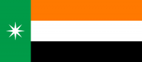
The 8 point star is a traditional symbol, signifying the merging of the 8 kingdoms into the new Kingdom of Saelaod. It is present on the flag and used by many government organisations.
The flag has an unusual height to length ratio of 10:23. This represents the creation of the Saleaod Kingdom in 1023, which would ultimately lead to Salide's unification beginning in 1474 and its rise as a world power.